October 1998
<<<
Thursday, 1 October 1998
We spoke too soon about Indian summer, since today was cloudy for most of the
day, but still pleasantly warm. On route to Baker City,
Oregon we crossed the 45th parallel, putting us
level with southern France and exactly halfway between the north pole and the
equator. Most of the route was through pleasant countryside with mountains in
the distance. There is a book titled "The Lost Continent" which is about Small
Town America and describes very well our own experiences of such places. We
passed through several such towns today. They all tend to be sleepy places,
miles from anywhere, with a wide main street and not much else. As we drive
through, nothing appears to be happening, other than perhaps a dog wandering
across the road. Any vehicles moving, crawl through at 15 miles an hour. Such
main streets have a gas station, a diner, perhaps a bar and little else. It
makes us wonder what everybody does and how they make a living.
The much larger Baker City was our destination for the day, which lies on
the route taken by the early pioneers as they moved through the plains to the
west coast. The countryside is a vast grass undulating prairie land, intermixed
with sagebrush. At this time of year, it is a dry, brown landscape, except near
towns where extensive irrigation brings the land to life. During the afternoon
we drove through some of the backcountry, where, as we have found elsewhere, it
is now out of season. Most tourist facilities are closed and hardly anybody was
in the state recreation areas or along the river.
Friday, 2 October 1998
|
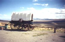
Intrigued by the numerous
Oregon Trail signs along the
roadside, we visited the nearby Oregon Trail
Interpretative Centre, where we were taken aback
by the impressive displays. Life-size models of
ox-drawn wagons, Indian camps and artefacts,
combined with modern audio-visual techniques,
powerfully demonstrate the extreme difficulties
the emigrants faced. More than 50,000 emigrants
travelled nearly 2,000 miles along the Oregon
Trail, during the period from 1843 to about
1880.
|
|
|
The journey from Missouri and Iowa would take them about 6 months, traversing
vast open plains, high mountain ranges and dangerous river crossings. Those who
survived the journey could claim one square mile of land per couple. However,
about 10% died from disease, heat, storms, starvation, accidents or at the hands
of occasional unfriendly Indians. Most Indians were friendly, providing food in
exchange for manufactured goods, and guiding the emigrants through difficult
terrain. Surprisingly, even 150 years later, it is still possible to see in a
few places the ruts left by the wagons. It is only by having travelled through
the endless terrain and by visiting such places, does one appreciate the full
enormity of what the emigrants endured.
Big day today, since we received our bulk mail from England, which is the first
time in nearly 5 months. On this occasion, we had some pleasant letters and no
unexpected bills!
Saturday, 3 October 1998
Autumn has arrived. It is still very pleasant during the day but colder at night
and it is now taking longer to warm up in the morning. Snowbirds are already
moving south to Arizona and the like. About halfway through today’s 125-mile
journey we crossed into Mountain Time and then over the Oregon, Idaho state
border before arriving in Boise. We only stayed the
night as the locality did not look too interesting. Valerie was a little
concerned when we heard on the radio that Wyoming has had several feet of snow
which is where we had considered going.
Sunday, 3 October 1998
Today’s 105-mile route was through vast open plains covered in sagebrush and
dried grass, interspersed with long mountain passes. We stopped in
Hagerman, which is known for its local fossil
beds. The fossil bed is a National Monument, famous for the numerous skeletons
of Zebra-type horses, found in the 600-foot bluff rising from the
Snake River. What is unusual, is many of the
3.5 million years old skeletons are complete and include young and old horses.
This has led to speculation that a herd of horses all died together in a massive
flood. We drove further along the Snake River to the Thousand Springs
Reserve, which is another oddity. Numerous waterfalls, many of which are large,
emerge out of the rocks on the side of the high cliffs along a stretch of the
Snake River. It is believed that the water travels underground from the
Lost River, which disappears into lava rocks
some 90 miles away.
Monday, 5 October 1998
|
|
|
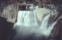
The nearby Snake River Canyon is
spectacular, being hundreds of feet deep, and
cutting into one of the world's great volcanic
plains. For hundreds of miles around there are
rocks of all sizes, still black from the
volcanic action of a million years ago. The town
of Twin Falls
received its name from waterfalls on the
Snake River, which is no more, following the
building of a hydroelectric dam in the thirties.
However, further along, the river is the
Shoshone Falls,
which are magnificent. While we watched, just
enough wind was blowing to create large moving
rainbows across the river far below us.
|
|
Even though less than 10 inches of rain falls
each year, farmers seem to have unlimited water
available to irrigate their fields, where we
even saw water mellows growing. Cattle farming
is also big business, but the sight of thousands
of cattle in small grass-less areas is
disconcerting.
|
Tuesday, 6 October 1998
A surprisingly quick 245-mile journey took us to
Salt Lake City in Utah which lies at the base
of the Wasatch Mountains. The I84 road
was good and almost empty. The scenery is mainly dry prairie with occasional
mountain passes. As we neared the border, the more angular rock mounds and
slopes typical of Utah started to appear. As we moved further into
Utah we travelled through a vast area which is regularly subjected to dust
storms, fortunately, there was no wind today. We camped in the middle of the
city, as we want to spend all day tomorrow exploring the downtown area.
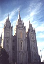
Wednesday, 7 October 1998
|
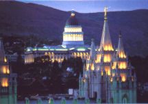
Salt Lake City
was occupied by the Mormons in 1847 led by
Brigham Young. The city first became the capital
of the Mormon settlement and then of the state.
It is a beautiful downtown with large concert
halls, churches, museums and fine commercial
buildings. To us, the most impressive area is
the Historic Temple Square, in particular the
Temple, Tabernacle and Assembly Hall Buildings.
It is a strangely peaceful place amid a busy
city. The main buildings are made from white
granite rocks, carried 20 miles by ox from a
mountain quarry. The beautiful Temple was
completed in 1893, unfortunately, it is not open
to visitors. We watched several brides having
their photos taken about 80 couples a day are
married in the Temple!
|
|
|
|
|
|
|
|
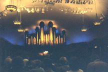
The Tabernacle has one of the largest organs in
the world with 11,623 pipes and the building
itself has remarkable acoustics. The organist
dropped a pin at one end of the building which
we heard clearly at the far end, some 150 feet
away. The music was incredible and at one stage
seemed to vibrate the seat and one's body.
During the Mormon's first year in the valley in
1847, crickets nearly devoured all the crops.
They prayed and were saved from starvation when
a huge flock of seagulls appeared and ate the
crickets. Not surprisingly the seagull is now
the state bird of Utah. In the afternoon
we watched "The Legacy", which is an elaborate
one-hour film depicting the struggles of the
Mormons as they were forced to move further and
further west. The FamilySearch centre has 150
computers, which the public can use free of
charge to trace their family tree. We spent some
time searching, but as the bulk of the records
are pre-1910, it is important to have detailed
information about one's grandparents to make any
progress.
|
|
|
|
|
The whole of the Temple complex is beautiful and built to a very high standard
and the way the numerous Mormon missionaries help and guide visitors is very
professional. They used every opportunity to encourage visitors to find out more
about their faith but in a way that did not offend.
Thursday, 8 October 1998
A disappointing day. We first visited the Old Dessert / "This Is the Place"
State Park to the east of the city. It was publicised as an extensive
re-creation of a Utah community in the mid-1800s. It turned out to be a
sparse, well-spaced village, with just a few log cabins, a social hall and
several adobe houses typical of an 1847-1869 pioneer community. However, even
staff in period costumes did not add much atmosphere or interest so we quickly
moved on.
Having had our interest kindled yesterday, our next stop was the Family History
Library in the centre of the city. It claims to have the world's largest
collection of genealogical information. Most of the collection focuses on the
United States, Great Britain and Mexico. Records date from 1550 to 1910. Among
the research tools available are microfilm, computers, reference books and a
family registry. We spent some time searching for relatives without success. We
found thousands of Garners, but having spoken to a few fellow searchers it seems
that one needs to devote days, if not weeks to the task.
Friday, 9 October 1998
Apparently, from space, it is possible to see two man-made features on the
Earth’s surface. The first is the Great Wall of China and the second is the
Bingham Copper Mine. The mine is a
huge, huge hole! It lies about 20 miles west of Salt Lake City and is the
largest man-made excavation in the world. It is more than 2 miles across and 3/4
of a mile deep. The scale of the operation is enormous. Each ore truck tyre is
12 feet high and costs $20,000, each truck carries 255 tons. After blasting, the
ore is loaded into a convey of these trucks and hauled out of the hole, then
dumped into a crusher, where the ore is reduced to about football size. The
crushed ore is then transported five miles via conveyer to the concentrator
plant. The ore only contains 0.6% copper, so it is mixed with water and
separated from some of the waste to concentrate the mix to 28% copper. The mix
is then piped 17 miles to the smelting factory, where it is turned into almost
pure copper, mainly for the electrical industry.
Saturday, 10 October 1998
We have concluded that it does not make a lot of sense to ship the RV home, so
we plan to sell it in Arizona. Phoenix should make a reasonable base for selling
the RV, its contents and the car, as well as a good location for our return
home. At present, it is still far too hot in Arizona (95F today) and as we have
some time to spare (we hope) before we need to get serious about finding a
buyer, we will dawdle a while in Utah. As Interstate 15 was being torn up
for miles, we left Salt Lake City via the I215 and then took the SR 6
east to Moab. Most of the route was through attractive
canyons, where the limited vegetation is now showing its autumn colours. At the
end of the canyon, we climbed to 7,500 feet, after which the landscape became
drier and more baron, with rocky cliffs extending for miles. After 185 miles of
pleasant driving, we camped in the small town of Green
River, which claims to be The Watermelon Capital of the World. It’s now
6.15 p.m. the sun is still shining, so it’s time to light the BBQ!
Sunday, 11 October 1998
Valerie did not feel like exploring so we had a lazy day at the campground. At
the moment the bread maker is trundling away making a sweet loaf for tomorrow's
breakfast - a somewhat Dutch habit we have picked up, but very nice. The TV news
is full of the major campaign just launched in England, to promote the Anglican
Church's new look. We wonder just how big the campaign is, or perhaps it is a
fill-in story. At the moment William Hague is on TV saying the Conservative line
is a wait-and-see, re the ECU - some things have not changed while we have been
away.
Our campground is directly opposite an almost empty golf course so it is a
puzzle why George has not grabbed the clubs, but it is not the same playing on
one’s own. Valerie has started to worry about how are we going to get everything
home, and what will we need to sell, give or throw away. If nothing else it has
started a mini spring clean and stuff has already been thrown away. Valerie is
planning to watch the 1998 Chelsea flower show in half an hour, so enough of
this idle chat, you probably have better things to do!
Monday, 12 October 1998
We initially visited Utah’s famous rock areas two years ago and enjoyed
every moment, so we decided to make a second visit en route to Arizona. By late
morning we had camped near Moab which is near both
The Arches and
Canyonlands National Parks. Later, on driving through the town we
were surprised at how little we could remember, other than The Slickrock Cafe
and its good food, which we will taste again before we leave the area. The area
is famous for the thousands of miles of 4X4 vehicle tracks as well as the
world-renowned Slickrock cycle paths. There are cyclists everywhere.
We revisited the Arches National park which was not as busy on this
occasion, and the rocks were just as spectacular. Massive arches, fins and
windows are the major features of the park, but the rocks come in all shapes and
sizes. Some huge free-standing rocks look like giant figures, while other
pinnacles precariously balance huge rocks on top. All the rocks are a beautiful
deep red or maroon, the colour of which appears to change throughout the day.
Delicate Arch is still our favourite formation, it is difficult to comprehend
how nature could have formed such a huge free-standing arch.
Tuesday, 13 October 1998
|
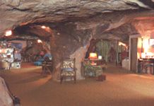
Our first stop of the day was "The Hole in the
Rock" house. People are strange. In this case, a
couple spent 20 years blasting and digging rock
out of a massive sandstone cliff to create a
5,000-square-foot home. Unfortunately, the man
died of a heart attack before it was finished.
The rock house has a lot of interconnected rooms
but no doors! The house includes a kitchen, a
large lounge, a bathroom as well as several
bedrooms. A big advantage of building the house
deep into the rock is the temperature rarely
goes below 65F or above 72F, so no heating or
air conditioning is necessary.
|
|
|
We have driven along many scenic routes however the UT128, which winds its way
along the edge of the Colorado River, must
be one of the most spectacular. The river has carved a long, deep winding
canyon, such that massive sandstone cliffs tower high above the river. In many
places, the shear rocks soar 1,000 feet or more above the river, along the top
edge of which eagles were circling for prey. The road was almost empty so we
were able to enjoy the beauty and the quiet of the area at our leisure.
After about 18 miles we took the La Sal Mountain
Loop road, where we were in for another treat. The road climbs for some distance
along which we had spectacular views of the valley and rocky terrain in the
distance. Higher up we were into the trees, which were stunning in their autumn
colours. The leaves of the cottonwood, oak and maple trees were brilliant
colours, ranging from bright yellows to dark reds. All of a sudden out of the
trees three cowboys appeared, to whom Valerie took a fancy. They were rounding
up cattle, no doubt in preparation for the coming winter. Further on several
groups of deer watched us as we passed by. It is a vastly remote area and easy
to get lost, as tracks and trails appear and disappear into the bush in all
directions.
Wednesday, 14 October 1998
|
|
|
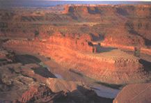
After our second visit to the Slickrock Cafe
(delicious), we drove into
Dead Horse
State Park. The park sits at the end of
a narrow point which towers 2,000 feet above the
Colorado River. From the viewing
platform, we had a breathtaking view of the
winding river and the vast canyon it has
created. The panorama is similar to that of the
Grand Canyon, albeit not so deep. We were
somewhat puzzled by about ten or so very large
bright blue, purple or white rectangular areas
on the canyon floor far below. On checking at
the visitors centre we learned it was a potash
mine, which we may visit tomorrow.
|
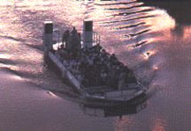
|
After dusk, we boarded a jet boat which took us
up the Colorado River for the Canyonlands
by Night experience. As the sun set and the
shadows lengthened, our imagination turned the
features on the massive riverside sandstone
cliffs into a series of weird figures and
animals. After about three miles the boat
stopped in the middle of the wide river and then
suddenly, the towering cliffs were illuminated
by 40,000 watts of light. At the same time,
stirring music started making it a very unusual
experience. We watched the powerful light play
all over the canyon walls for about an hour,
during which an audio narration unfolded the
story of the canyons' pre-historic beginning,
through to the recent settlement by the white
man. It was a good end to the day, made better
by being a pleasantly warm evening.
|
|
|
Thursday, 15 October 1998
With miles and miles of off-road tracks in the locality, George could not resist
the opportunity to put the Suzuki through its paces. About halfway along UT279,
we came across 1,000-year-old Indian petroglyphs, carved into the side of the
sandstone cliff. Further on were several dinosaur footprints, but they were too
high for a close look. Soon afterwards the road turned into a twisting dirt
track full of hollows, bumps and loose rocks. The track wound its way through
the flat bottom of a huge canyon cut by the Colorado River. The
surrounding rocks towered about 2,000 feet above us. After 10 miles or so,
without seeing any living thing, we came to the potash mine and its vast
processing lakes. Each lake was a mile or so long and about a quarter of a mile
wide, each seemed to be a different shade of blue or purple. The road then
became even rougher and we were being bounced all over the place, even when
moving at only a few miles per hour. Other than a few birds there were not any
signs of life for miles around. By now Valerie was getting worried about what if
we broke down etc. etc. Anyway, the car did get us back OK and George enjoyed
playing pioneer for a while!
Friday, 16 October 1998
A wet, cold and overcast day, so we spend most of the day vegetating.
Saturday, 17 October 1998
The sun was shining when we arose, so we quickly decided to cut a dash and move
further south, in case winter decides to set in early! On route, we were not too
surprised to see snow had fallen on the La Sal Mountains, where only two
days ago we had such a beautiful drive. We camped in
Monument Valley, which we visited with Doug & Ivy a year ago, almost
to the day. The approach from the north is through a long plain adorned with
strange rock formations, which stand like giant statues along the horizon. The
unique Mexican Hat rock formation has not
changed, which is not surprising since it has been there for thousands of years.
However, all of the Indian roadside stalls were closed which might say something
about an early winter. The whole area is Navajo Land and parts of the valley are
sacred, so visitor access is restricted or only possible with an Indian guide.
Most of the best rock formations can be driven around in your car, bringing back
memories of old western films, as the rocks have been used as a backcloth for
numerous movies.
Sunday, 18 October 1998
The Valley of the Gods, Utah was
today’s destination. It turned out to be an 18-mile dirt road which took two
hours to drive due to the very rough surface. The view was interesting but we
have been spoilt by so many other splendid views during our travels. We only
encountered two other cars, so not a good place to break down, which was again
in the back of Valerie’s mind. We ended at the base of a sheer 2,000-foot rock
face, where it did not seem possible there could be a route to the top. However,
a tortuous single-track, switch-back dirt road clung to the rock face. We slowly
ascended to be rewarded with a magnificent view of a vast flat plain which
extended for tens of miles.
Monday, 19 October 1998
George wanted to have another look at the Grand Canyon,
so with a slight detour, we camped at the Trailer Village RV Park, which is a
few hundred yards from the canyon. The long uphill approach to the canyon is
covered in Pinon and Juniper trees, whose berries seemed ready for picking. We
have now seen the Grand Canyon about six times, but it still stirs our
hearts and mind with its vastness and beauty. The evening ranger talk was again
very good, this time focusing on the wildlife within the national park, which
surprisingly, includes black bears on the North Rim.
We are now at 7,300 feet which takes a little getting used to since exercise can
make one quickly breathless. The high altitude also means that it is cooler,
particularly at night, much to Valerie’s delight.
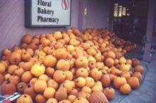
Tuesday, 20 October 1998
|
Cloud slowly gathered as we moved to the town of
Williams, which
lies about 60 miles south of the canyon. Time to
stock up on the larder etc. as we expect to
spend some days in Congress, which lies
in a somewhat remote location. Vast quantities
of pumpkins on sale at the local supermarket
confirm that Halloween is just around the
corner.
|
|
|
Wednesday, 21 October
The overnight thunderstorms turned into the rain for most of the day. Time to
catch up on the travelogue, Email and letters. A phone hook-up meant we were
able to have a two-hour NetMeeting with Kevin and June. Claire-Marie read from
her book for a while and then practised her French on us, luckily it was all for
the price of a local phone call.
Thursday, 22 October 1998
The SKP park at Congress is one of George’s
favourite RV parks, having scenic views, good company, large sites and a quiet
location. On route to the park, we descended about 5,000 feet, most of which was
down a long narrow and very winding mountain pass. The descent was not helped
when, too late, we noticed that vehicles over 40 feet were not allowed! Upon
arrival, we found that the temperature had gone up about 15F, which is par for
the course for this part of Arizona. Valerie decided it was time for a hairdo,
leaving George to have a siesta.
Friday, 23 October 1998
We are in luck as the campground has organised a yard sale for tomorrow. This is
an opportunity too good to miss, for us to sell some of the RV contents. It is
surprising how much we have accumulated over the past three years, which meant
spending most of the day preparing for the sale.
Saturday, 24 October 1998
The sale went very well. We sold more than we could have reasonably hoped for
and surprisingly hardly anybody haggled over the price. This might be an
American characteristic or maybe our prices were too low, but at the end of the
day, we were both more than satisfied. We still have a lot left, but most items
we will need most until our departure. Finding buyers at the last moment for the
rest of the stuff will be difficult, we, therefore, expect to give most of what
remains to charity.
Sunday, 25 - Tuesday, 27 October 1998
|
Other than a trip to
Phoenix on Monday, where we may have
located a buyer for the ham radio, life has been
mainly cleaning, chewing the cud and watching
the sun rise and set. Most nights we are awoken
at some stage by the sound of the coyotes in the
desert. Sometimes it is so loud we get the
impression that a pack are waiting for everybody
to go to bed so they can scavenge the
campground.
|
|
|
Wednesday, 28 October 1998
We moved to Mesa, AZ putting us closer to several RV
dealers, which we plan to visit in a few days. By coincidence upon arrival at
the campground, we met a German couple who are also trying to sell their RV,
before returning home.
Thursday, 29 - Saturday, 31 October 1998
We recently had a voicemail message from an English couple, who had just read
our letter which was published in the English American Motor Home Club magazine.
It turns out they are touring the US in a motor home which they purchased
earlier this year. Talk about a coincidence, since it turns out they have camped
just five miles away! We met up with Ray & Prue Nipper, who turned out to be a
very nice couple. They are halfway through an 18 months tour of the US, after
which they plan to ship their motor home to France, where they have recently
purchased a house. We had a really enjoyable time, sharing experiences and views
of the US etc. Ray has been involved with American motor homes for some years
and is one of the founder members of the UK club. He believes strongly that we
should ship the RV to England, where, even if we sold it in a year or so, we
would still be better off financially. We will decide on Monday after visiting a
few RV dealers. Other than finding a buyer for the ham radio, the rest of the
time was spent enjoying the really pleasant weather.
>>>
Home