April 1998
<<< Wednesday,
1 April 1998
We had previously visited California
wine regions a year ago and enjoyed the beautiful rolling hillside scenery.
This time we were able to tour more extensively so gaining a fuller appreciation
of the vast size of the wine production area, which includes the Napa, Alexander
and Sonoma regions. Throughout there are numerous wine tasting
opportunities located in upmarket and picturesque buildings, several of which we
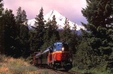
stopped to visit. Pat had arranged for us to have a private tour of the Arrowood
vineyard which was conducted by the wine maker. Today was the first day of
the year for bottling and just like many factories they we having numerous
equipment problems. After the tour we were able to taste some of their excellent
private wines but at typically $30 a bottle we kept our money in our pocket.
Somewhat surprisingly to us adjacent to the Arrowood vineyard was a brewery
which was established about 10 years ago. The owners believed, it seems
right, that by growing hops locally together with a plentiful supply of good
quality local water they could produce some unique beers. Dick and George on
putting the beer to the test were disappointed to find that the best beer was
not available for takeout sale.
We both enjoy Mexican food so Pat and Dick proposed that we should eat at
Juanetta's, which from the outside looked like it should be that last place on
earth one should eat, however, the food turned out to be excellent which says
something about external appearances. We then visited the home of Pat's son
which has a large pond in which they are rearing trout by the thousand as well
as many geese. A large collection of fishing equipment, guns, cars and farm
tools adorned the walls of the large single-story home where we exchanged
experiences over a glass of excellent wine.
Thursday, 2 April 1998
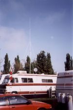
George having acquired a Ham licence over a year ago could
no longer put off the urge to purchase a transceiver, so the first thing he was
off to Radio Shack where he purchased a mobile VHF unit which fortunately was on
sale. Following an overdue haircut, it was then off with Dick to a meeting
of SIR's (Sons in Retirement) which is a non-profit organisation for retired men
for the promotion of independence and dignity of retirement. This turned
out to be a very enjoyable luncheon meeting attended by about 150.
Following various announcements and information from common interest groups
including golf, fishing and travel outings, the meeting was closed with an
excellent comedian telling jokes about the folk from Louisiana.
Friday, 3 April 1998
Dick offered to show us the
Humbolt area which is where
he was born and raised, so we set off in both RVs through mixed rain and
sunshine for the 180-mile drive north to our first stop at
Benbow, which marks the end
of the wine region and the start of the lumber industry. En route, we
visited Real Goods at
Hopewell
which is a world-famous solar energy store where every item the environmentally
conscious person desires could be purchased, including radios powered by a
clockwork mechanism and a shaver driven by a pull cord. The northern
section of the route passed through tree-covered mountains and deep valleys
through which the Eel river flows, which is designated as a wild river and as
such does not have any dams along the whole of its length.
Saturday, 4 April 1998
The
Benbow
Valley RV Resort includes a 9-hole par 35 golf course, which is empty and free
to campers was too much of a temptation, so Dick and George went off to play
while Pat and Valerie explored by car. Halfway around the golfers were
somewhat surprised when alerted by gunshots and the appearance of the sheriff,
which did not help improve the golf.
|
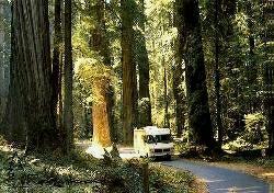
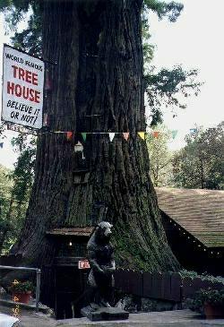
During the afternoon we drove along the 101,
stopping to inspect the so-called
World Famous Tree House
which is located near
Piercy,
California. It is a
4,000-year-old living tree 250 feet high, 33 feet in diameter and 101
feet in circumference. Its unique feature is a room built in a
50-foot-high cavity within the tree and as always the attraction
includes a tourist gift shop.
|
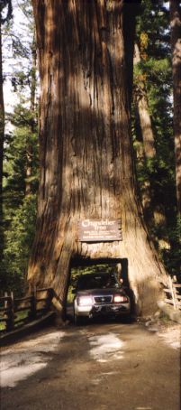
It was then on to see the
Chandelier Tree
near Leggett,
California which is a Drive-Thru Tree towering
315 feet into the air and with a diameter of 21 feet. We drove
through the hand-hewn opening at the base of the tree in the Suzuki
stopping for the compulsory Kodak moment.
|
| |
|
 |
 |
| |
|
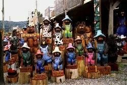
We are now in a big foot country, well at least in one of
the many areas where sightings have been reported, some of the local roadside
shops display wooden carvings of the big foot as well as postcards and books
which document reported sightings.
Sunday, 5 April 1998
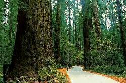
Our route to Fortuna
was via the Avenue of the Giants
in Humboldt county which is a 33-mile section of highway
paralleling US 101 between Phillipsville and Pepperwood, winding mainly along the
course of the Eel River. While the
surrounding hills also support oak, maple, madrone and pepperwood trees, the
magnificent redwoods along the road overshadow them all.
We parked for a while and followed a trail into the forest
which was eerily quiet and fairly dark, one could not fail to be impressed by
the size and age of the silent giants surrounding us. A few of the trees
had died but even lying on their sides the trunks still towered above us.
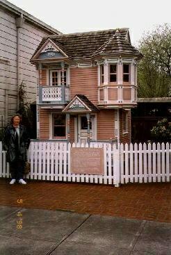 |
During the afternoon we drove into
Ferndale which reached via
the 101 via the oldest reinforced concrete bridge in the US. The
town which had fallen on hard times managed an economic recovery in the
1960s by making an excellent job of refurbishing its numerous Victorian
houses, which now sell a wide variety of tourist items A
local craftsman had built a replica Victorian house which any child
would love to play with, in this case, the occupants were three bears
|
|
Monday, 6 April 1998
Dick took us on a guided tour of Loleta
and the surrounding countryside which is where he was born and
grew up. We learnt a lot about the lifestyle of the time
and like most folk he still has a strong affection for his roots
and is perhaps a little saddened by the changes that the passage
of time always brings.
Tuesday, 7 April 1998
|
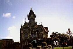
Exploring
Eureka which is the only town of any size
for tens of miles around, we found in the downtown area many
well-preserved Victorian-styled houses and shops which sell some unusual
gifts and gadgets, which even managed to get George interested.
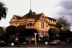
One notable building is the ornate Victorian
Carson Mansion which reflects the days of the lumber barons,
today it is a private club.
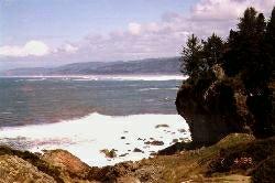
We visited a few of the local State parks including
Patrick's Point which affords
magnificent views of the huge Pacific waves crashing and boiling on the
rocks far below. Later we watched a seal fighting with the
seagulls for fish while we had a late lunch at the Seascape pier-side
restaurant in Trinidad.
Trinidad was first discovered by
the Portuguese in 1595 but it was not until the gold rush days in the
mid-1850s that the town developed. Later it was the turn of the
loggers who also recognised the value of the natural harbour and then in
the 1920s, the whalers used the same facilities.
|
 |
 |
Wednesday, 8 April 1998
The Pacific Lumber Company
is a vast complex located in the Company's town of
Scotia and close to the Eel River, which can have
its downside since in 1964 the river flooded the whole mill to a depth of 8
feet. The mill offers free self-guided tours which should take an hour,
however, George and Dick became so engrossed that it took nearly two hours.
The company owns huge areas of forest from which it continuously cut down mainly
redwood trees which are transported to the mill by road. Upon arrival a
crane offloads a full load in one lift, placing the logs into the bark removal
facility. The bark is removed from a huge log in less than three minutes
by blasting water at 12,000 gallons per minute onto the log. The bark is
then conveyed away to make other products, in fact, nothing is wasted though out
the whole of the wood production process since any waste including the sawdust
is used to fuel the company's electricity power generation plant.
The stripped log is then conveyed to one of several sawmills and quickly cut
into planks, the operator of which has to be very skilful to ensure each log
produces the maximum of planks with the minimum of waste. Planks are then
cut to various lengths, planed and stacked. What we found surprising was
the large-scale use of glueing small pieces of wood together to form excellent
quality large planks and boards. The company plants five new trees for every one
it cuts down and claims that its redwood trees grow faster and are of better
quality than those left to nature.
There cannot be many campgrounds with a micro-brewery within a few minute's
walk so it was put to the test and Dick and George found the beer to be as
excellent as the previous evening, however, the evening was more than made when
George won the first prize in the draw; a free nights stay at a local bed and
breakfast hotel as well as two theatre tickets.
Thursday, 9 April 1998
It was time to say goodbye to Pat and Dick who were returning home to
celebrate Easter with their family.
|
As luck would have it the hotel had the best room
available tonight and evening seats were also available for the theatre,
so we decided to take a break from the RV. The Bartlett House Bed
and Breakfast hotel turned out to be a delightful Victorian-style house
surrounded by an English-looking garden and was located in a quiet part
of
Ferndale. High-quality redwood had been used
throughout the house and our room was furnished with a range of quality
antique furniture. Upon arrival, we were served refreshments and
the following morning we were treated to a gourmet breakfast.
|
|
 |
Friday, 10 April 1998
Having found out that our site had access to a phone hook-up, George spent
most of the day resolving why the computer Internet connection had not worked
for some months. The problem was fixed by the end of the day so he
celebrated by downloading numerous files, and running up the CompuServe charges!
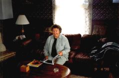
Valerie caught up on her reading.
Saturday, 11 April 1998
We awoke to heavy rain and dark skies which we understand is normal for this
time of year so we postponed our plan to travel further north until tomorrow.
However, as the forecast for the next few days is similar we may not avoid
travelling in the rain. It is no coincidence that the redwoods which must
have prolific quantities of water grow so well in this part of northern
California.
We lost a set of keys a few days ago so we drove into Eureka
in an attempt to obtain replacements but as always it turned out that a few of
the keys are special and nobody stocked the blanks, so we now need to find a
locksmith. On the way, we could not help noticing that numerous
rhododendrons and azaleas were in full bloom which must make the season about
one month ahead of England's spring.
Kevin has been rightly chasing for more photos to include in the home page so
we spent some time sorting out negatives and obtaining prints which we will mail
on Tuesday.
Sunday, 12 April 1998, Easter Sunday
Some months ago we decided that we would like to explore
Oregon and perhaps parts of Washington
before joining the rally to Alaska in mid-May, however, we knew
that the weather was likely to be wet but El Nino
seems to be trying to ensure that every day is wet. It was dry when we set
off for the 133-mile drive to Brooking,
Oregon where we stayed at the Harris State park which is within
50 yards of the beach. Within an hour of leaving Fortuna,
the rain returned and stayed with us for the rest of the journey. North of
Eureka the 101 frequently ascended affording pleasant views of
the coastline which is partly indented with inlets, lagoons and lakes. The
low-lying parts of the coastline are subject to the effects of tsunamis; very
high waves caused by earthquakes out to sea can suddenly appear and cause
serious damage.
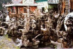
Due to the vast forests, masses of driftwood accumulate along much of the
northern Californian and Oregon beaches.
The small community of Orick almost totally
depends on driftwood by converting it into animals, windmills or strange
artistic shapes and then selling it to passing tourists.
The 101 road is only two lanes wide in many places and the
steep sides of the coastal hills are subject to constant landslides resulting in
an ongoing battle to keep the road open. At
Klamath
{, so that's where Bill Gates got the codename for his
Pentium processor! - Ed} we stopped and walked in the rain through the
Trees of Mystery
which is a forest of old redwoods, many having grown into weird shapes.
Along the trail is excellent carvings mainly made by Paul Bunyan who it's
claimed was a super-human logger. The entrance which is through the roots
of a fallen giant redwood tree is dominated by a replica of Paul standing over
100 feet high.
For some weeks stores have been full of multicoloured eggs and
dying kits which today being Easter Sunday were being given as
presents by the basket load or hunted in “Find the Easter
egg” competitions which appear to be popular all over the
country.
Monday, 13 April 1998
Brookings'
claim to fame is that about 90 per cent of the country's Easter lilies are grown
locally, we found out by accident that lilies unsold the day after Easter could
be purchased for less than a dollar each. Commercial fishing, lumbering, making
wood products and tourism are
Brookings'
largest industries. The only aerial attack on the mainland United States by a
Japanese warplane during World War II occurred just east of the town, which has
a population of about 5,500. During a break in the rain, we explored the
state park's picturesque beach after which we managed to find a locksmith who
made the rest of our keys. We drove north along the coast road in heavy
showers trying to enjoy the sea views, stopping in the town of
Gold Beach
where we spotted a delightful campground located on the beach so we decided to
move tomorrow.
Tuesday, 14 April 1998
 |
|
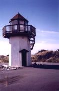
Contrary to the weather forecast the sun came out
as we set off for
Gold Beach about thirty miles to
the north. As the Ireland Ocean View RV Park was almost empty we
were able to select a site with a good view of the sea. A
lighthouse is located within the grounds of the campground which we
climbed to inspect the wide expanse of beach and watch the huge Pacific
waves. After lunch, we drove a 20 miles circular loop around the
Rogue River. This is a
wide attractive river along which numerous fishermen were after the
salmon. Ten miles inland a State park provides access to a wide
pebble beach alongside the river where about 40 RV's were camped in a
perfect setting.
|
Wednesday, 15 April 1998
Even though the map showed several roads through the
towering
Klamath mountains we were unsure
if they were yet open after the winter snows and landslides. We decided to
go by car and take a chance since the route followed the deep canyon formed by
the fast-flowing
Rogue River
which for a hundred years or so was the only way to access the region.
Even today US mail boats still run up the river, and today tourists can book a
half or full-day trip, we would have loved to do this but the boats do not start
running until May the first. As it turned out we were only able to drive
about 40 miles into the canyon before we found all the through routes to
Grants Pass
closed.
Thursday, 16 April 1998
|
Having successfully set up the ham radio in the car
George decided that it would be nice to also use it while travelling in
the RV. This presented an opportunity to make an antenna since one
could only be purchased by mail order and we did not want to wait
several days for it to arrive. So after several trips to Radio
Shack and the local hardware store, and some hours of assembly and
installation on the RV roof, it was tested and worked surprisingly well.
Valerie was thankful that George did not build an antenna like the RV in
the adjacent site which extended 30 feet about its roof!
|
|
 |
Friday, 17 April 1998
Oregon
has many scenic routes so we were spoilt for choice and were having difficulty
deciding which direction to head next when George got into conversation with a
fellow camper. He lived locally and strongly recommended taking the SR199
to
Grants Pass as the road follows
the course of the
Smith River
which he claimed is one of the most beautiful rivers in the world. We
decided to give it a go even though this meant backtracking about 50 miles.
Just past
Crescent City,
the road was blocked by a landslide and traffic was only being allowed through
every two hours. If nothing else being in an RV we were better off than
the car drivers since we were able to have our lunch and make a cup of tea while
we waited.
By the time the two hours had passed the tailback was
several miles long, we all crept slowly passed the landslide which looked as if
at any moment tons more rock could come crashing down. We found the route
along the
Smith River to be pleasant but
overstated. Our destination was the Riverpark RV resort near
Grants Pass and our site was on
the edge of the
Rogue River,
let's hope it does not rain or Valerie will be awake all night checking for
flooding.
Saturday, 18 April 1998
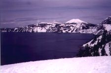
Even though it would be a round trip of 190 miles the postcard
pictures of Crater Lake
looked attractive so we decided to pay a visit. As it
turned out it was a truly spectacular vista, well worth the
journey. Most of the route to the lake was through miles of
fir forests, at about 5,000 feet we were above the snow line and
by the time we arrived at the rim of the crater the snow
was towering 10 feet above the car.
|
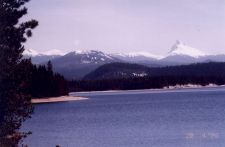
Crater Lake
was formed when the
Mount Mazama volcano collapsed about 7,700 years ago
and today with a depth of 1,932 feet it is the deepest lake in the
United States. The view is spectacular with the deep blue lake
lying 900 feet below the snow-covered rim which is at an elevation of
7,200 feet. At one end of the lake is
Wizard Island
which further adds to the lake's overall beauty. We would have
liked to have driven around the rim but the snow was so deep that the
circular rim drive is only open from July to September. What was
surprising was that even though the lake is surrounded by snow for most
of the year it rarely freezes completely over due to it's extreme depth.
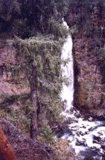
During the return journey, we visited several waterfalls and a fish
hatchery where we learnt that
Oregon raises 75 million fish
per year, over half being salmon.
|
|
 |
Sunday, 19 April 1998
A short and scenic drive along Interstate 5 brought us to
the pleasant SKP campground in
Sutherlin, where we spent the
rest of the day odd jobbing. During the evening George watched the regular
weekly broadcast of the prime minister's question time on C-SPAN, which always
leaves us feeling that foreigners must think the British have a very odd
parliamentary system.
Monday, 20 April 1998
Valerie suggested a trip to
Diamond Lake which lies
about 50 miles to the north of
Crater Lake
and about 80 miles east of our campground along the OR138, which follows the
course of the
Umpqua River.
Umpqua is an Indian word meaning full belly however this did not apply to us
since we set off just before lunch completely forgetting not only is it still
out of season but also the route was into an area without habitation or
facilities, so it could have been a good day to start a diet. The lake turned
out to be beautiful. It was frozen, covered in snow, miles from anywhere
and surrounded by snow-covered hills and perhaps just as importantly no other
humans for miles around. After viewing the attractive two-drop
Toketee Falls
which are accessed via a long walk through a tree-lined ravine, we stopped in
Glide where the
Umpqua and
Little Rivers
meet head-on, which is claimed by the locals to be unique if nothing else causes
some local turbulence!
Tuesday, 21 April 1998
Having seen little of the coast during our tour of the USA
we decided to head west again so we could then travel north along the 101 which
closely follows the
Oregon
coastline. We normally get a good idea of the type of scenery to expect on
the route from the local guide books but no mention was made of the pretty route
from
Sutherlin to
Reedsport via SR138 and 38
The road follows the course of the
Umpqua River which has now become much wider and slower as it
flows through attractive tree-lined valleys. As we neared
Reedsport we found an elk
viewing area which we decided not to explore since the only visible elk looked
small in comparison to the herds we saw in
Michigan last summer.
Experience has taught us that upon arrival in a new
location we quickly come to similar conclusions as to whether we like what we
see or not and on this occasion we unanimously decided to give the towns of
Reedsport and
Winchester Bay
a miss. We turned north eventually camping in
Florence which appeared to
be a more interesting location. In general access to the beach is
difficult due to the extensive dunes and housing developments however we reached
the beach near the harbour where we watched clams and crabs being sucked up from
the sand with what appeared to be a large bike pump.
Wednesday, 22 April 1998
|
The
Oregon Dunes National Recreation
is a huge area extending along 40 miles of coastline from
Coos-Bay to
Florence. The dunes have
an average height of 250 feet and at the widest point, the area extends
inland about 2.5 miles. We took several walks into the almost
deserted dunes but by far the most interesting part of the day was the
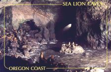
visit to the sea lion cave which lies about 10 miles north of
Florence.
It is the only cave in the US used by seals and can only be accessed by
boat or via an elevator which descends 208 feet through solid rock into
the 1,500-foot-long cavern. The cave is a magnificent sight with the
huge Pacific waves crashing through the west entrance and hundreds of
seals lying over the rocks or swimming playfully in the waves.
|
|
 |
Thursday, 23 April 1998
 |
|
Fortunately, George decided to check the RV tyre
pressures before moving on since one of the tyres turned out to be
punctured, which if nothing else provided an opportunity to put our
breakdown service to the test. Thankfully they did a good job,
changing the wheel within an hour of reporting the problem.
Unfortunately, the tyre was beyond repair so after parting with 145
dollars we had a new spare and continued north stopping for the night at
the South Beach State Park near
Newport.
Newport has a large commercial
fishery which is located on the attractive
Yaquina Bay but as it was
raining we contented ourselves by just visiting the waterfront shops.
|
Friday, 24 April 1998
After an early morning walk along the deserted beach, we
travelled 160 miles northeast to
Portland and the Jantzen
Beach RV Park which is located on
Hayden Island in the
Columbia River,
opposite an excellent shopping mall. Oregon
is one of the very few states which does not have a sales tax, which on the
surface should make purchases cheaper, however, in our experience, everything
seemed to be more expensive than say
California
or
Arizona. It is also the
only state we have come across where you cannot pump your gas so protecting a
large number of jobs. It is somewhat subjective but George did not find the
people in
Oregon as friendly as many other
states we have visited.
Saturday, 25 April 1998
The
Portland
downtown craft and flee market is a “not to be missed” venue for any tourist.
After getting lost several times we explored the large number of stalls which
had some unusual items, but on this occasion, Valerie kept her money in her
purse. Directly opposite the campground is a shopping centre with all the
major outlets in particular the main computer shops including Circuit City, Comp
USA and Computer City. This was too much to resist! George spent
some hours wandering through each shop in turn and it was no surprise to Valerie
that he ended up buying some new computer software.
Sunday, 26 April 1998
Our routine of late seems to be to explore locally on the
first day at a new location, followed by a day out in the car further afield and
the third day doing little before moving on. Today being the second day in
the sequence found us on a 195 miles loop around
Mount Hood, which is a huge
11,200-foot high conical snow-covered mountain east of
Portland. The route out
was along the
Washington side of the huge
Columbia River Gorge which rises
shortly after leaving
Portland.
Our first stop was at
Fort Cascade National Historic Site where for about fifty
years from 1880 huge fishing wheels were used to scoop masses of salmon from the
river until outlawed in 1934 (the wheels not the salmon).
The next stop was at the Bonneville
lock, dam and power house which was opened in 1937, a second
power house was added in 1981. Extensive fish ladders allow the
half a million or so adult salmon a year reach the up stream
tributaries of the Columbia and Snake Rivers, however
the young ocean bound fish have to be transported downstream in
barges. A viewing area enabled us to see a number of 20 lb.
Chinook Salmon swimming frantically against the fast flowing
water.
|
We continued along the
Lewis and Clark Trail
crossing the river at the
Bridge of the Gods to
Cascade Lock,
which for early settlers marked the point where the tremendously
difficult terrain from the east ended since the rest of their journey
westwards was an easy boat ride along the tidal part of the
Columbia River. The town whose locks were
submerged when the
Bonneville dam was built
provided a delightful restaurant overlooking the river where we had our
lunch before turning south and through the large fruit orchard area.
By accident, we stumbled on the delightful village of
Parkdale which affords
impressive views of
Mount Hood
and is the turnaround point for the dinner train ride from
Hood River. The road
circling the beautiful
Mount Hood
provided access to numerous state parks and snow play areas which is
possible for most of the year since the mountain remains snow-covered.
|
|
 |
Monday, 27 April 1998
The showers of a few weeks ago had left the RV looking
somewhat in the need of a good clean and being the spring
cleaning season, it was time for action. It normally takes
about half a day to wash the RV however George decided to scrub
the whole roof as it had not been done since it was purchased,
this resulted in chalk streaks from the rubber roof all down the
outside, so the second half of the day was spent washing the
outside, the ground and then George!
Tuesday, 28 April 1998
We set off today intending to travel to the
Washington coast however about
15 miles into
Washington
after stopping at a combined rest area and visitors information centre, we
learnt that
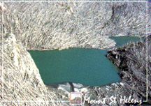
Mount St. Helens
was only 80 miles to the northeast so we decided to change our plan. As
well as useful information we were supplied with free coffee and cookies which
is fairly typical of some of the State Welcome centres we have come across.
After leaving the RV at the campground we drove to the
Mount St. Helens visitors centre
which graphically displays the events leading up to the catastrophic eruption in
May 1980, the subsequent damage and the aftermath. As well as an excellent
slide show a Park Ranger also gave a presentation which added a more personal
touch to a disaster in which 57 people died, many of whom may be alive today if
they had taken the advice of the experts.
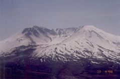
Wednesday, 29 April 1998
|
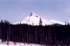
Today was an awe-inspiring day. Initially, we
drove east along route 504 towards
Mount St Helens,
stopping occasionally to look at the pleasant mountain scenery which
however changed into areas of devastation when we were about 15 miles
from the volcano. Even 18 years after the eruption tens of thousands of
fallen trees still lie on the slopes and the deposits from the enormous
mud and plasma slides can still be seen for miles along the Toutle
valley and river. Triggered by an earthquake the volcano exploded
with the force of 500 atom bombs blowing the top 1300 feet off the
mountain and scattering millions of tons of rock for miles around.
The eruption produced a 650 miles an hour wind that snapped every tree
for miles like match sticks and the heat blast killed every tree within
a 15-mile radius.
|
|
 |
|
There are several interesting visitor centres and
viewing points, the most impressive is the
Johnston Ridge Observatory.
The observatory is not only the closest to the volcano but has an
excellent film of the eruption which ends with the screen rising and
revealing a huge window through which the audience can see the
snow-covered volcano. We had excellent weather for our visit which
was hot and calm, very similar to the day it happened, which did not
help Valerie’s uneasiness being so close to a sleeping time bomb!
|
| |
|
|
Thursday, 30 April 1998
We decided to move to the
Washington coast since it may be the last opportunity to visit
the coastline for some time. The 113-mile drive to
Copalis Beach was
uninteresting and became even more so as we approached the coast. This is being
written at three in the afternoon sitting in the RV at a beach side campground
overlooking the Pacific ocean - sounds good? - well it would be if we were not
surrounded by thick fog! The weather inland was gloriously hot and sunny
but as we approached the coast it became cooler and foggy made worse by a thick
dust cloud that had been blown from China
>>>