July 1998
<<<
Wednesday, 1 July 1998
Today was the case of the unexpected. Mid-morning as we were about to drive into
town we noticed smoke about a mile away towards the end of
The Spit, so we decided to be nosy. It turned out to be a
large fire in a fish packing factory. After watching for a while we left The
Spit and drove into Homer for some shopping.
About an hour later we came across some of our travelling companions who
informed us that everybody (several thousand people) had been forced to leave
the Spit. Large quantities of chlorine and ammonia were on fire and the
experts had decided it was safer to let it burn itself out. By late afternoon
the local high school had been opened for the hundreds of people like ourselves
who had nowhere to go or stay since our RVs were still in the evacuated area. By
early evening the local TV and Radio had arrived to interview some of the
"homeless". We were then informed that it would not be safe to reopen the
Spit until the following morning but cots would be available for the
overnight stay in the school. At which point we quickly decided to take an
(expensive) room at the local motel, just managing to get one of the last
available. The fire was the main item on the 10 p.m. news where we were
surprised to see ourselves being interviewed. To further add to the excitement a
4.2 earthquake occurred during the afternoon!
Thursday, 2 July 1998
The Spit was finally reopened at 9 a.m. even though a huge plume of smoke
was still rising from the factory. Two of the RV’s in our caravan decided to
stay on for the salmon fishing but we left with Bill, Bev, Leo & Barbara. We
camped on the sea edge in the Ninilchik State
Park Recreation Area about 40 miles north of
Homer and watched several eagles fishing as the rain continued
throughout most of the day. Later we learnt the Spit was evacuated again
during the evening when another cloud of ammonia was emitted.
Friday, 3 July 1998
As it was the Independence Day holiday weekend the campgrounds would be full, so
we decided to return to Soldotna and stay in Fred
Meyer’s car park until Sunday. To pass a rainy afternoon we went to the
Kenai National Wildlife Refuge
visitors centre. After watching an interesting film about the salmon life cycle
we took the trail to the lake but were chased back to the car by mosquitoes. As
we were returning to the RV a large female moose and her two babies calmly
walked across the road in the centre of the busy town.
Saturday, 4 July 1998
As our local town did not have a parade, we drove into Kenai arriving
just in time to watch the Independence Day parade. Laundry and correspondence
filled the rest of the day.
Sunday, 5 July 1998
On route to
Seward,
we passed the
Russian river
where salmon fishing was still in full swing, however, we found watching a moose
wallowing in a waterway close to the road to be much more enjoyable. After a
fairly slow two-hour drive we arrived and camped on the edge of
Resurrection Bay.
Seward
is a small but important fishing port and a centre for boat tours of nearby
glaciers which we plan to take during the next day or so. As this is being
written we are watching several sea otters playing in the bay which is almost
surrounded by snow-capped mountains.
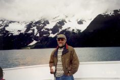
Monday, 6 July 1998
Early on we spent a few interesting hours in the
Alaska Sea Life Centre
but today’s highlight turned out to be the evening wildlife viewing cruise. The
sea life centre was funded out of the Exxon Valdez oil spill settlement, to
preserve all forms of ocean life through research, rehabilitation and education.
In 1989 some 450 miles of coastline were badly contaminated with oil and even
today many species such as Stella Seals have not fully recovered, some may never
recover from the disaster.
|
From the moment the evening dinner cruise ship
left the harbour we seemed to be in luck as in
no time we were watching the unusual (to us)
sight of a Humpback whale within the bay.
Further on two bald eagles watched us from the
top of a dark green spruce tree, while at the
same time sea otters were laying on their backs
having their evening meal. The boat edged close
to the cliff edge in several places where
puffins, cormorants and numerous other birds
were nesting, Further on seals were resting on
rocky outcrops and then suddenly we found
ourselves in the middle of a pod of Orcas
(killer whales). We must have watched them for
nearly an hour and at one stage they were
swimming under our boat.
|
|
|
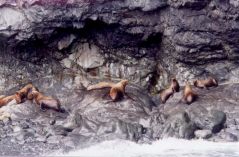
Tuesday, 7 July 1998
Six miles outside Seward lies the Exit Glacier
which descends 2,500 feet from the Harding
Icefield. A half-mile climb led to the edge of the glacier, the wind
became significantly colder and chunks of ice were breaking off at random. The
glacier is slowly being pushed downhill by its massive weight at about five
inches a day but has receded about half a mile during the last hundred years.
The cause is unclear but global warming is thought to be partly responsible.
Wednesday, 8 July 1998
|
|
|
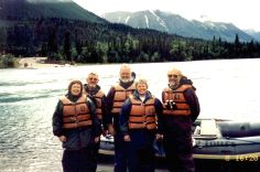
Five of us decided to take a float trip down the
River Kenai
in an inflatable dingy. After donning masses of
waterproof clothing and life vests we were soon
into the centre of the wide, fast-flowing river.
The river was in flood which meant the four-hour
trip only took three hours and much of the white
water excitement was a non-event since there was
too much water over the rapids.
|
|
The
Kenai
is a world-class trout and salmon fishing river
and as we passed the confluence of the
Russian River
numerous fishermen were standing in the river up
to their thighs competing for fish. In places,
they were almost shoulder to shoulder, so close
that their eyes can be easily injured by hooks.
We saw very little wildlife but several bald
eagles watched from treetops whilst a large
female moose completely ignored us. It was a
windy, cold trip and raining by the time we
thankfully arrived at the landing stage.
|
Thursday, 9 July 1998
After moving the RV’s to Portage we boarded a train
to reach the town of Whittier, which does not have
any road connection, from where our boat trip to the glaciers of
Prince William Sound departed. The
train consisted of four double-deck passenger coaches and numerous flatbeds upon
which rode vehicles of every description. After about forty minutes traversing
two long mountain tunnels and some attractive scenery we arrived in Whittier,
where 6O of us board a 40-seat school bus for the short ride to the boat!
Whittier
was built by the army in 1943 as a supply base but today the 300 or so
inhabitants depend on fishing and tourism for their livelihood. Strangely they
all live together in one of two buildings which helps to reduce heating bills
and the need for snow clearance.
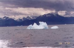
|
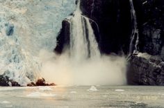
For the first hour, the boat moved northwest
through the calm waters of
Passage Canal
en route to the glaciers. The scenery was
magnificent. We were surrounded by snow-covered
mountains, and blue-green water and even the sun
was shining. As we moved into
Blackstone Bay
the glaciers started to grow larger and larger
until they towered 1,700 feet over our boat. We
floated at the base of several glaciers for some
time, surrounded by icebergs.
|
|
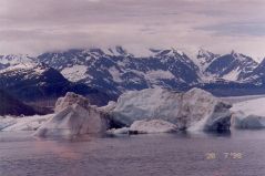
We listened to the ice cracking and groaning as
its massive weight pushed it down the mountain
and into the sea. Without warning the glacier
would suddenly calve off enormous quantities of
ice into the sea, making the boat rock as the
waves hit us. Glaciers have a strange blue hue
appearance giving an almost eerie look. Ice
worms, which are about an inch long and no
thicker than a pencil line, live within the ice,
eating algae and pollen trapped within the ice
crystals.
|
|
|
In the evening Leo and George went to find a phone to sort out a problem with
Leo’s computer but did not return for four hours, causing Barbara & Valerie to
quite rightly get worried. Locally there are very few phones, none of which
would work with Email, so they ended up travelling the 45 miles to
Anchorage.
Friday, 10 July 1998
|
|
|
After a somewhat late start, we went for a short
walk and realised that a small glacier was on
the hill just behind the RV. George spent more
time helping Leo with his computer. Bill & Bev
said goodbye as they needed to return home. Late
afternoon we explored locally and were somewhat
surprised to find that the area had so many
hidden attractions. A visitors centre contained
a good display explaining the formation and life
of glaciers. Boat trips could be taken to view
the nearby
Portage Glacier
but we drove on to
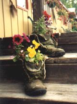
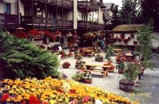
Alyeska
which is a small alpine-looking village
containing masses of colourful flowers in
hanging baskets etc. The flowers grow twice as
big as we are used to seeing, presumably due to
the very long daylight hours.
Alyeska
is a large ski region with a very upmarket hotel
where we treated ourselves to an enjoyable
evening buffet-style meal.
|
|
|
|
|
|
|
|
|
Saturday, 11 July 1998
Morning spent teaching Leo more about the OzWin computer programme, while
outside the rain fell. Later on, started to complete the tax return but quickly
concluded that our lifestyle does not fit easily into the tax form structure.
Watched the glacier for a while. While out driving yesterday we noticed a very
busy restaurant so we visited it this evening and had a first-class meal. On the
way back to the campground we stopped at
Tangle Lake
and watched a beaver gather a leafy branch, swim with it in his mouth across the
lake and then bury it in the lake bed next to his lodge. It was still very light
at 10.00 pm so we all went for a walk along a trail which took us to the edge of
a large snow field. We could not believe how much water was flowing under the
ice, forming large tunnels that a walker on the snow could easily drop into.
Sunday, 12 July 1998
With time to spare and as we are thoroughly enjoying the
Kenai
Peninsular, we decided to backtrack and spend a few more days in
Seward,
which we consider to be one of the most attractive places we have visited. Leo &
Barbara left for
Anchorage
so our caravan has now dispersed but we expect to meet up soon with Dick & Pat,
our friends from California. The town of
Seward
is named in honour of William Seward who orchestrated the purchase of
Alaska
from the Russians in 1867. Upon arrival, we went to the water dump station and
almost immediately Pat and Dick drove by. Later we spent some time sharing our
travel experiences over an enjoyable meal in the Apollo restaurant.
Monday, 13 July 1998
|
|
|
It was a beautiful sunny day so during the
morning we mainly enjoyed the excellent view.
After lunch, we walked to the
Chugach Heritage Centre
to watch an interesting play about the legends
of the Chugach Indians. At about 10 pm as we
strolled back from our evening meal, we were
surprised to see three black bears wandering
across the hillside behind our campground. It
was made even more interesting as no more than a
few hundred yards away we could also see several
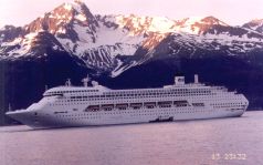
walkers on a path converging with the bears. At
10.30 pm a huge P&O cruise liner pulled out of
the harbour, it looked impressive in the sunset
against the snow-covered mountains.
|
Tuesday, 14 July 1998
We spent some time enjoying the view and then watched a film about the massive
earthquake which struck
Alaska
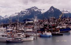
in 1964, followed by a couple of hours in the local museum. The local waters
have large quantities of huge halibut, so providing a major fishing industry and
a pastime for tourists. Halibut is considered small at around 30 lb. and fish
over 300 lb. are regularly caught. We watched for some time large quantities
being unloaded and then immediately filleted at the dockside. We both like
halibut, so we purchased some at 2 pounds a pound to stock up the freezer.
Wednesday, 15 July 1998
Dick and Pat wanted to visit
Homer
so we left for
Anchorage
having agreed to meet up en route to Vancouver. As we passed
Portage
we noticed several vehicles parked at the side of the road. About 100 yards away
a brown bear was slowly circling an RV, which was camped on the edge of a creek.
The occupants were inside so they must have had an excellent view. For hundreds
of miles, we have seen countless Black Spruce trees either dead or dying. A
beetle is responsible for having already killed millions of trees in Canada, it
has now reached the forests of
Alaska.
Camped in the Walmart car park for the night, it’s now 10.30 pm and still broad
daylight we have not seen the sunset for weeks.
Thursday, 16 July 1998
After finally resolving a problem caused by our building society we moved camp
to the outskirts of
Palmer,
which lies 35 miles northeast of
Anchorage.
The snow-covered peaks of the
Chugach
and
Talkeetna
mountains rise above
Palmer,
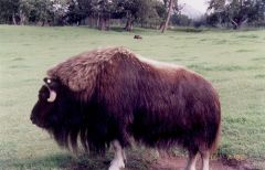
a city surrounded by lush pastures, where the long daylight hours enable
cabbages to regularly grow to over 70 pounds! (What a lot of coleslaw) Nearby is
the Musk Ox Farm which has around 50 of these prehistoric animals, that came
close to extinction at the turn of the century. The shaggy creatures are valued
for their fine under wool called qiviut. Eskimos knit the hair, which is eight
times warmer by weight than wool, into hats and scarves. Valerie decided she did
not need a new hat when told they start at $150 each.
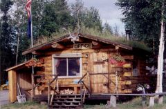
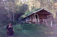
The campground office is a small log cabin which in the local tradition, has the
roof covered in soil for additional insulation, enabling a profusion of
attractive wildflowers to grow on the roof. Valerie will probably have
difficulty sleeping tonight since the local TV news programme announced that
campers need to be especially careful as there are a lot more bears about this
year! However, George’s only worry whilst BBQ cooking, was that the mosquitoes
were back!
Friday, 17 July 1998
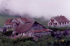
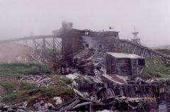
During the peak year of 1941, the Independence
Mine produced 34,416 ounces of lode (hard rock) gold. Today most of the
buildings have collapsed and the mine is boarded up.
During the peak year of 1941, the
Independence Mine
produced 34,416 ounces of lode (hard rock) gold. Today most of the buildings
have collapsed and the mine is boarded up. However, the ruin is very photogenic
and almost attractive in its way. A few of the buildings are being tastefully
restored but the rest are too far gone. From within the ruins, a Hoary Marmot
stared unconcernedly at us as we took its picture. After enjoying lunch and the
view from the lodge, we drove along part of
Hatcher Pass.
It is a badly potted gravel road, which climbs 3,800 feet before descending into
a long deep green valley. We saw plenty of colourful wildflowers, and an eagle
but no wild animals.
Saturday, 18 July 1998
The first 80 of the 140 miles to
Glennallen
are fairly torturous. The road constantly climbs several thousand feet and then
immediately descends back down to the edge of the wide, fast-flowing
Matanuska River.
After passing through 9 miles of gravel the road suddenly improved, but numerous
deceptive frost heaves sent the suspension shuddering to the stop. We were the
first of the day to arrive at the Tolsona Wilderness campground but by early
evening the camp was full and we had a couple on holiday from Germany as
neighbours.
Sunday, 19 July 1998
|
The 140-mile drive to
Valdez
was along almost empty roads. To the east, the
peaks of the 16,000-foot
Wrangell Mountain
range invited us to take a closer look another
day. The final approach into
Valdez
is over the 3,800-foot
Thompson Pass
where some 70 feet of snow falls in an average
winter. Probably world famous for the 1989 oil
spill, the small attractive town of
Valdez
is almost fully surrounded by 5,000-foot-high
snow-covered mountains. Apart from the pipeline
terminal fishing is the major industry, both
commercial and private, with numerous charter
boats for hire in the attractive small-boat
harbour.
|
|
|
|
On pulling into the Eagle campground we were
greeted by the sight of fishermen admiring and
filleting the day's catch, mainly salmon and
halibut. Around the town notices state "The
silvers are in" indicating that the Coho salmon
have started their run upstream. For a few
weeks, there will be a frenzy of fishing, since
during the peak 30,000 salmon a day swim to
their spawning grounds. However, the local TV
reported that for the second year running the
number of returning salmon is very low.
|
Monday, 20 July 1998
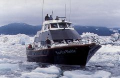
Having enjoyed several boat trips we decided to take the six-hour trip on the
Lu-Lu Belle to see the
Columbia Glacier,
which is the second-largest tidewater glacier in North America. The boat which
was fitted out with plush carpets, beautiful wood and comfortable seats, was
soon cruising at twenty knots into
Prince William Sound.
Some distance offshore a family of cute-looking sea otters were resting on their
backs and further on a large group of Stella Sea Lions were also resting on a
rocky shore. Everybody became excited when a mother Minke whale and baby were
spotted. We slowly followed them for a while trying to guess where and when they
would next surface. At one stage they were no more than 30 yards from our boat.
About 10 miles from the glacier we started to see a few large icebergs which
became an impenetrable barrier about six miles from the glacier. The boat came
to a crawl as it edged its way through the pack ice, while we delighted in the
variety of shapes and colours which ranged from pure white to iridescent blue
and even black caused by the rocks picked up descending the mountain.
Tuesday, 21 July 1998
|
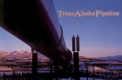
Valdez
is the southern end of the
Alaskan oil pipeline
and the terminal for container ship loading. We
toured the complex where we learnt that oil
arrives at the end of the 800-mile-long 48-inch
diameter pipeline at about 70,000 barrels an
hour. It is then either directly loaded into a
container ship or a storage tank. Sea water used
as ballast in a tanker’s crude oil holding tanks
becomes contaminated with residual oil. The
ballast water is pumped ashore and immediately
treated to remove oil and other contaminants and
then released into
Port Valdez.
Booms are always placed around all ships being
loaded and it’s claimed that in 1997 less than
one cup of oil was spilt during the loading of
800 oil tankers.
|
|
|
Wednesday, 22 July 1998
|
|
|
We have now travelled as far into
Alaska
with the RV as we sensibly can and driven along
most of the main roads, excluding the very long,
rough road to
Prudhoe Bay
near the
Arctic Ocean.
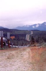
Today we started our return journey. We had been
warned that major construction work was in
progress on 50 miles of the
Tok
cut-off, so we decided to go via
Delta Junction,
so adding 125 miles to our journey. It probably
was a better route, however continuous frost
heaves for the first 40 miles shook every part
of the RV and then annoyingly a passing truck
flicked a stone, making a large chip in the
windshield! For most of the 260-mile journey,
the almost empty road followed the oil pipeline,
which has numerous bends to allow for the
expansion and contraction caused by temperature
changes and to accommodate earthquakes. Arrived
in
Delta Junction
late afternoon.
|
Thursday, 23 July 1998
It rained for most of the day so we were pleased that it had stopped by the time
we boarded the 7.00 p.m. bus for a four-hour evening wildlife tour. The most
pleasing part of this type of tour is that the driver/tour guide is local and
therefore full of interesting information. We found several moose with young,
all standing almost neck deep in the water eating the weeds. The driver
explained how a lot of Alaskans who live outside the towns exist on what they
can fish, hunt and collect in the way of the numerous berries which grow wild.
They heat their small homes with wood. Asked what everyone does in the long
Winter months he told us of the outdoor activities including dog sledging,
skiing and watching the Northern Lights. In temperatures of -50F you can throw a
cup of hot coffee in the air and it freezes before it hits the ground! Most cars
have a power plug hanging out of the front which is plugged into a power point
at work or home. This heats the engine oil, water, battery and sometimes the
driver's seat so ensuring an easy start since the temperature regularly plummets
below zero during the winter. It used to be said that if you came to live in
Alaska
you were either running from a woman, the law or the IRS (tax men).
Friday, 24 July 1998
Other than unexpected road construction the 110-mile drive to Tok was
uneventful along an almost empty road. Masses of bright pink Fire Weed
wildflowers lined the roadside for mile after mile. Upon arrival, the 230 site
campground was almost empty but by four p.m. it was full, made worse when a
large caravan party arrived and a mad RV washing rush ensued. Spent some time
debating if we dare take the very poor dirt road to
Dawson City tomorrow or give it a miss, the forecast is for heavy rain,
but came to no firm conclusion.
Saturday, 25 July 1998
Awoken in the middle of the night by the sound of rain, which to George
signalled to give Dawson City a miss. However we were both up early and
the weather looked OK, so against Valerie’s advice we set off for Dawson City.
After thirty miles of paved road, it rapidly deteriorated. For the next 80 miles
it was horrendous washboard, dips and pots holes which shook ourselves and the
RV so much we were amazed that nothing broke. Halfway along and in the middle of
nowhere is the gold mine town of Chicken,
population 33. The original miners wanted to name the town Ptarmigan after the
state bird but did not know how to spell it, so settled on Chicken! The
few remaining miners are still reworking the tailings which were first discarded
during the gold rush of 100 years ago.
We were sad to leave Alaska as we had enjoyed its spectacular scenery and
unique lifestyle more than any other state we have visited. The land of the
midnight sun causes one to reconsider lifelong habits, like what determines when
it is time to rise or retire. Going out at 11.00 p.m. to explore or take a walk
becomes normal. We have come to understand what is meant by the spell of the Far
North, which is why so many return for another visit. We would love to return
but for now, Canada and in particular Vancouver Island calls.
Once across the Canadian border and into The Yukon
the road was paved, so we were able to relax more and enjoy the splendid views
along the very well-named Top of the World
Highway. This road is built along the top of numerous interconnected
4,000-foot or so mountains. We could see for miles in every direction. A long
descent and a free ferry took us across the fast-flowing, murky
Yukon River into Dawson City, which is
probably the most famous of the gold mining towns. Finding a campground site was
a problem since several caravans had arrived just before us.
Sunday, 26 July 1998
Flowing into the
Klondike River
near
Dawson City
is
Bonanza Creek,
in the bed of which gold was discovered in 1895, so starting the world-renowned
gold rush. By the time the news reached the outside world, the stampeders were
too late as claims for the whole area had already been placed. Most of the gold
was mined and the real money was made later when mechanised mining was
introduced. We could not believe our eyes when we saw the restored Dredge No 4
which is one of 26 mechanised gold mining dredges used during the first half of
the twentieth century. Dredge No 4 is huge, being 145 feet long, 65 feet wide,
75 feet high and weighing 3,000 tons. It is a barge that makes its lake float
on, by digging the gold-bearing soil at the front, sorting out the gold on board
and then depositing the tailings over the rear. It only took four people to
operate but another 100 to thaw out the frozen soil in front of the dredge, with
enormous quantities of cold water. Today the whole area looks like a giant
earth-eating worm has moved through the valley leaving circular rock waste
trails.
Monday, 27 July 1998
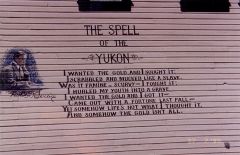
At 10.00 a.m. we took our seats in the garden of the Robert Service log cabin,
for a fascinating storytelling presentation of his life and poems by Tom Byrne.
After an unusual start to life, first as a hobo and then as a successful banker,
Robert Service wrote hundreds of beautiful poems which superbly capture the
essence of the North and life during the gold rush days.
Later we joined a walking group for a narrated tour of the town. Due to the
permafrost, all the roads are still gravel with wooden sidewalks, giving the
impression of an old western town, particularly as most of the buildings date
back to the early 1900s. One of the interesting comments made by our guide was
about the ice break-up on the Yukon. The whole town has a wager on the
date and time that the ice breaks up, which is normally during the first two
weeks of May. A tripod is placed on the ice with a wire tied to a clock on
shore, when the ice flows it stops the clock as well as sets off the town fire
alarm, bringing everybody running to watch the event.
The RV had not been pulling too well when climbing mountains recently, which
George put down to an ignition problem. This was confirmed and fixed by the
local garage during the afternoon. We were fortunate to be seated in the royal
box for the Gaslight Follies presentation at the Palace Grand Theatre, but we
only rated the show 5 out of 10. As the sun was still shining after the show
finished at 10.40 p.m. we wandered the town for a while and then drove up to the
Midnight Dome. This is a mountain top
overlooking the town with marvellous views of the Yukon and Klondike
rivers.
Tuesday, 28 July 1998
The new North West Highway commemorative
first-day cover stamps went on sale today. This seemed to be quite an event for
the town and at 10.30 a.m. along with about one hundred others, we were sitting
in the road outside the Post Office for the unveiling. It was entertaining as
many of the local dignitaries attended dressed in 1900-style costumes. After the
presentations to local organisations including the RCMP, we were all treated to
a free buffet lunch, not bad considering we did not buy any stamps!
The visit to the town museum was disappointing, as was George’s attempt during
the afternoon to make his fortune panning for gold in a local creek. It was arm
and back aching work, giving a taste of the hardship experienced by the miners
of long ago. During the evening we attended a fascinating talk by a 70-year-old
gold miner who had marvellous tales of his experiences trying to make a living
"laundering dirt". He spoke fondly of the camaraderie amongst gold miners and
the local towns folk but had some scary stories of close contact with the
numerous bears in the area.
Wednesday, 29 July 1998
It’s now 11.05 p.m., and the sun is still shining brightly on our mountaintop
campground which is just a few miles south of the
Arctic Circle.
Peace at long last, after a noisy, bone-shaking journey along a 225-mile badly
potted, narrow, gravel road. Valerie is now convinced George is mad having
driven the RV all this distance along the
Dempster Highway,
which is one of the loneliest roads in Canada. A vast emptiness is one
description of Northern Canada and to some degree it is true. During the
nine-hour drive, we saw less than 25 vehicles, two small campgrounds, endless
Black Spruce and masses of beautiful wildflowers. Every vehicle is the same
colour, dark brown, as absolutely everything is covered in thick mud.
Unfortunately, we have not yet seen any wildlife but maybe tomorrow.
Thursday, 30 July 1998
After yesterday's very difficult driving conditions, we decided to continue
north along the Dempster Highway in just the car. We soon crossed the
Arctic Circle where we stopped for the obligatory photo ceremony. Forty
miles further on we crossed into the
Northwest Territories, which is an unbelievably large province with
virtually no population or roads. After climbing the
Richardson Mountains, the scenery
became more open tundra with occasional lakes but other than an Arctic Fox, no
wildlife showed itself during the whole 306-mile round trip. It is a vast
wilderness area that other than the highway has hardly been touched by man. In
two places the road doubles as the local emergency runway, so we had to watch
above as well to the front and rear of the car.
A free ferry took us across the Peel River and
shortly afterwards we arrived in Fort McPherson.
This was a strange place. After four hours and 110 miles, we needed a pit stop
but we could not find a restroom anywhere. We asked several of the local
Gwich’in Dene Indians but were informed that there weren’t any, and neither
could we find a restaurant or hotel. For years the town was only assessable by
water or air but the building of the highway in 1982 must have made a big impact
on the town. We listened to their local radio station with interest, which
implied that alcoholism was the town's number one problem. All the houses are
built on wooded pads to avoid melting the permafrost, also all pipes are above
ground. The town's claim to fame is the Lost Patrol; in 1911 four members of the
Royal Canadian Mounted Police got lost and froze to death. Another 40 miles
north and the terrain became flat as we reached the vast
McKenzie River, which drains one-fifth of
Canada’s water. After some hesitation we decided not to take the Arctic Red
River ferry to go on to Inuvik, which is as far
north as one can go by road, as the terrain looked flat and uninteresting, also
based on our Fort McPherson experience, hotels etc. might be a problem.
Friday, 31 July 1998
Interesting how the weather can influence one’s opinion of an area. When we
drove up the
Dempster Highway
two days ago, the cloud was low and with occasional rain, it was difficult to
see the full panorama and came to the opinion that the scenery was interesting
but not exceptional. However, today as we backtracked, it was dry and with the
clouds much higher, we could see clearly in all directions. For over 150 miles
the scenery was very enjoyable, with continuous mountain ranges, green valleys,
rivers, creeks and tundra-covered hillsides. It was all very pleasant, the only
thing missing was wildlife. We saw a few birds, an occasional ground squirrel
but considering the vast area, we covered it seems that vegetation rules the
roost in this part of the world. Again the very dusty road was almost empty, but
we were very surprised when a camper with GB number plates suddenly passed,
going in the opposite direction. My, it felt good to be back on paved road at
mile zero, where we spent over an hour trying to wash some of the thick mud from
the RV, the car will have to wait until tomorrow.
>>>
Home